Ben Udlamain
The snowy cairn of Beinn Udlamain, the highest of the 3 Munros, and furthest back form the A9.
Looking west from Beinn Udlamain over Loch Ericht towards the snowy massif of Ben Alder
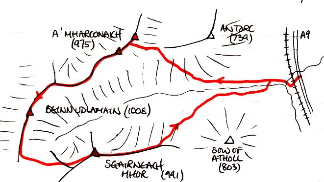
A' Mharconaich, 975m, Beinn Udlamain, 1011m, and Sgairneach Mhor, 991m
|
Date: 11/03/84 |
Tops and Munros |
|
Companions: Conan Fischer |
|
|
Distance: 16km | |
|
Climbing: 800m | |
|
Time: 8 hours | |
|
Weather: Clear and crisp | |
|
Munro Tally: M48-50, T77-79 | |
|
An early start from Edinburgh to make the most of the short winter day. As the dawn broke, we realised it was going to be a pefect, blue sky day. Our only worry was that the A9 had been cleared of snow, but that every layby was filled with the stuff. Where would be able to park? Fortunately, when we reached Drunochter, we found that the very layby we wanted to use was the only one which had been cleared of snow! The snow was soft and deep in places, but we made good progress round this circuit of broad ridges. The views were exceptional, and we had no difficulty crossing the river as it was completely hidden under the snow blanket. | |
|
Ben Udlamain The snowy cairn of Beinn Udlamain, the highest of the 3 Munros, and furthest back form the A9. |
|
Looking west from Beinn Udlamain over Loch Ericht towards the snowy massif of Ben Alder | |||
|
|
Sgairneach Mhor Conan beside the half submerged trig point and cairn on Sgairneach Mhor. | ||||
|
|
<< route maps of the day's walk
To see an OS 1:50000 map showing A' Mharconaich, click here
To see an OS 1:50000 map centred on Beinn Udlamain, and showing Sgairneach Mhor, click here
To see a road map of the area around these mountains, click here | |||||
|
return to Mountains home page |
Comments or questions? david@dbethune.com |