Beinn Dearg
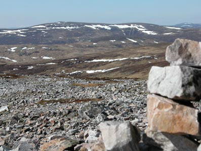
Looking across to Beinn Dearg from our lunch spot on Beinn a' Chait. A bleak deserted moorland ...
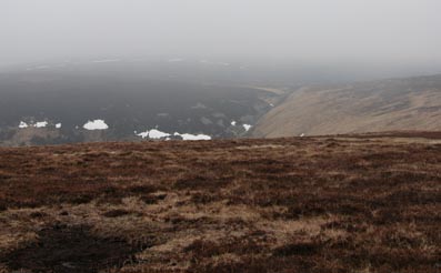
Fortunately the cloud lifted a couple of 100 metres before we reached the summit. Very little snow after a warm, dry spring.
Beinn Dearg, 1008m
|
Date: 9/4/2003 |
Tops and Munros |
|
Companions: Anne |
|
|
Distance: 16km walk + 14 km cycle | |
|
Climbing: 550m walk + 300m cycle | |
|
Time: 8 hours | |
|
Weather: warm day, cloud base rising from 800m to 1000m | |
|
Munro Tally: M151, T259 | |
|
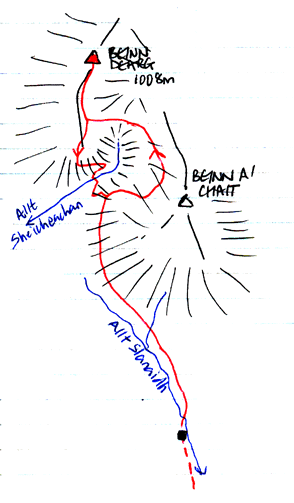
Beinn Dearg had been reproaching me since February 1985, when I had set out to climb it with friend Conan Fischer. Unfortunately we found deep soft snow as we reached higher ground. My short legs soon tired trying to keep up with Conan's long strides, so i turned back over Beinn a' Chait, and waited for him in the bothy in the valley of the Allt Slanaidh (now no longer there). Otherwise, it might have been my 59th Munro. So, it was with a feeling of determination that Anne and I set off from the car park at Old Blair on our bikes 18 years later. It was slow going on the bikes - up some steep hills, then onto a rougher track through the forest. A puncture delayed us for a while, but we continued to the site of the former bothy by the Allt Slanaidh before leaving our bikes and continuing on foot. Although not shown on the OS map, a land rover track continues all the way up the side of Beinn a' Chait to a junction. We took the right hand fork, steeply uphill on to the plateau-like top of Beinn a 'Chait. Lunch was taken resting against a large prominent boulder, looking across to beinn Dearg, still topped by cloud. We contoured across the dried up peat bogs to the col , then up the gentle grassy ridge of Beinn Dearg. The cloud lifted as we approached the final rocky 100m to the large summit cairn, 2 hours 45 minutes from leaving the bikes. We descended down the south ridge, following a zig zag stalkers path to the Allt Sheicheachan, in its narrow glen. A short steep ascent took us back to the outward route, which we followed back to our bikes. We hadn't seen another soul all day! The bikes proved their worth as we freewheeled downhill through the forest. Unfortunately, we had another puncture at almost the same spot. Even so, we were back at Old Blair within an hour. Back in Pitlochry, we enjoyed a meal at the Indian restaurant, before retiring to a lovely log fire in Craigroyston House B&B. | |
|
|
Beinn Dearg Looking across to Beinn Dearg from our lunch spot on Beinn a' Chait. A bleak deserted moorland ... Fortunately the cloud lifted a couple of 100 metres before we reached the summit. Very little snow after a warm, dry spring. | ||||
|
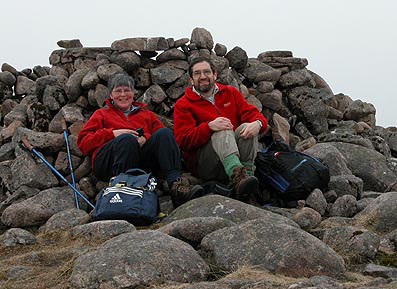
Beinn Dearg summit >>> Anne and I at the summit cairn. These were the first mountain photos using a new Nikon Coolpix 5700 digital camera (abandoning my trusty old Pentax K1000), so I was able to use the self-timer to get a picture of us both!
Plan of day's route (below)
|
|
|
|
Beinn Dearg from Carn a' Chlamain Looking across to Beinn Dearg from Carn a' Chlamain the next day. Our ascent and descent of Beinn Dearg were along the gentle ridge leading up to the summit from the left.
| ||||
|
To see a road map of the area around this mountain, click here If you want to see a 1:50000 OS map of the mountain, wait until the road map is displayed by streetmap.co.uk, then click the third "house" from the left on the zoom symbol, which will be displayed below the road map:
|
|
return to Mountains home page |
Comments or questions? david@dbethune.com |