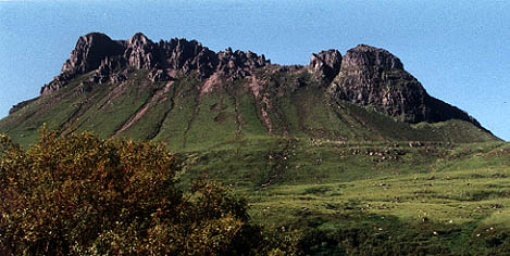
Stac Pollaidh from Loch Lurgain
You can see the scar of the very eroded path up to the bealach - which is a stupendous viewpoint arrived at very suddenly.
We managed along to the second last bump from the left!
Stac Pollaidh, 612m
|
Date: 23/6/79 (1) and 19/797 (2) |
Tops and Munros |
|
Companions: Nigel Orr (1) and then with the whole family (2) |
|
|
Distance: 4km | |
|
Climbing: 500m | |
|
Time: 3 hours | |
|
Weather: | |
|
Munro Tally: | |
|
The first ascent waas with friend, Nigel Orr, while backpacking out from Ullapool YH. The weather was fine (but the next day it started raining, and continued for 72 hours without a pause!). I contented myself with the second last pinnacle, while Nigel completed the scramble to the actual summit. The next visit was on a scorching day in July 1997. The family were camping at Ardmair Point, and we followed the usual route up the south side. The slopes were much more eroded than they had been 20 years earlier. It felt like climbing a sand dune! Anyway, all of us (myself and Anne, plus Iain (14), Catherine (12) and Fiona (9)) all managed to get on to the ridge. We scrambled along most of the way towards the summit, but turned back when it got a bit tricky. Getting back to the bealach was actually more difficult, as we missed the paath we had followed earlier, and had to traverse some tricky slopes. We returned down the north side, and followed the path around the east end of the hill. Enjoyed cooling our feet in Loch Lurgain afterwards. | |
|
|
Stac Pollaidh from Loch Lurgain You can see the scar of the very eroded path up to the bealach - which is a stupendous viewpoint arrived at very suddenly. We managed along to the second last bump from the left! |
|
Loch Lurgain from Stac Pollaidh Oh, dear! This is what I looked like back in 1979. |
|
|
|
Stac Pollaidh Pinnacles Two of the pinnacles on the south side of the ridge of Stac Pollaidh. Is this the "Madonna and child" or the "Lobster Claw". My own caption in "What did the dinosaur say to the woman?"
route map (1997) |
| |||
|
|
To see an OS 1:50000 map of this mountain, click here
To see a road map of the area around this mountain, click here |
|
return to Mountains home page |
Comments or questions? david@dbethune.com |