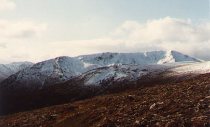
Tom a' Choinich, 1111m

Tom a'Choinich stands at the NE end of Glen Affric, to the south of Loch Mullardoch, between Toll Creagach and Carn Eige.

Date: 16/5/1981

Tops and Munros

Companions: with Anne and Marjory

  • Tom a' Choinich (M) 1111m

Distance: 15km

Climbing: 900m

Time: 3 hours up, 2 hours down

Weather: cold and windy on top

Munro Tally: M22, T32

I have only sketchy memories of this hill. Our base was Marjory's house in Inverness, and the mode of transport was her liitle Fiat 126!

We started from the Glen Affric road, towards the far end of Loch Beinn a' Mheadhoin, and followed the strong track up Gleann nam Fiadh. Easy going until we reached the Allt Toll Easa. We zig-zagged up the steep hillside on a stalker's path, then branched left onto the south ridge of Tom a' Choinich. Following a series of false summits, the ridge levelled out to the true summit at 1111m.

It was too cold and windy to linger, or to visit any of the tops further west, so we descended down the east ridge to the col, then back down the Allt Toll Easa to rejoin outr outward route.

Tom a' Choinich

View of Tom a' Choinich from near the summit of Toll Creagach, taken in October 1983.

The long south ridge of Tom a'Choinich is seen, with the sharp east ridge (our descent route) dropping directly from the summit.

Toll Creagach, by contrast, is a very rounded and convex hill.
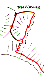
 

route map 1981

<<< route plan


To see a road map of the area around this mountain, click here

If you want to see a 1:50000 OS map of the mountain, wait until the road map is displayed by streetmap.co.uk, then click the third "house" from the left on the zoom symbol, which will be displayed below the road map:

return to Mountains home page

other mountains in this area

Comments or questions? david@dbethune.com